Wet, Chilly Weather Returns
Rain chances return to Green Country on Tuesday.Tuesday, February 7th 2023, 6:40 am


If you’re into podcasts or in a rush, check out my daily weather update. Search for NewsOn6 and ‘Weather Out The Door’ on most podcast providers, including Spotify, Stitcher and Tune-In, or Click Here to listen on Apple Podcasts.
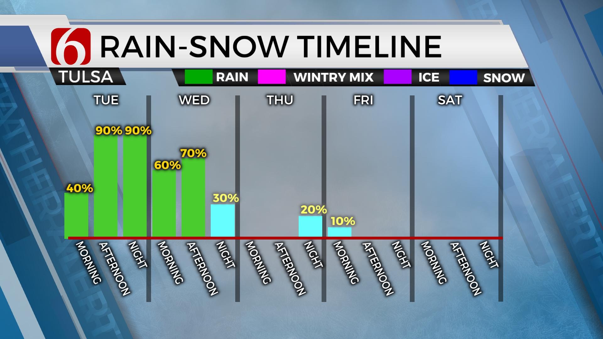
TULSA, Okla. - Rain chances return to Green Country on Tuesday.
Here are the details from News On 6 Meteorologist Alan Crone:

A chilly, blustery, and wet weather pattern unfolds on Tuesday through at least part of Wednesday with afternoon highs below normal. Temperatures will start on Tuesday morning mostly in the 40s near Tulsa and upper 30s across far northern Oklahoma with afternoon readings in the mid-40s with blustery north winds.

The front moved south of the metro earlier Tuesday morning with blustery northwest winds and cooler weather invading most of the region. A few scattered showers are currently underway but additional rain with some thunder will arrive throughout the day as the main upper-level system of interest remains to our west. This feature will slowly move east with additional rain, possibly locally heavy at times, later tonight into part of Wednesday. The general trend in the data on Tuesday morning continues with a slower ejection of the main upper-level low. We may need to keep some precipitation chances for part of early Thursday but have yet to insert those low-end chances. Precipitation will remain all liquid for the eastern third of the state with this first system. A small area of wintry mix, mostly in the form of light snow, will remain possible Wednesday evening as the main upper-level system begins nearing the state. These areas will remain near I-35 across north-central Oklahoma into south-central Kansas. A few snow showers may eventually sneak into northwestern Osage County late Wednesday night. The next fast-moving upper-level system drops down into the area late Thursday evening into early Friday with a low chance for some light snow showers, mostly across far northern Oklahoma and southern Kansas. Higher probabilities should remain north of our area but any change in trajectory could bring different probabilities.

Rainfall amounts beginning Tuesday and continuing through Wednesday, possibly early Thursday will result in 1 to 2 inches area-wide along and east of Highway 69, with locally higher amounts from 1 to 3 inches across part of east-central Oklahoma into western Arkansas. Local flash flood guides are not exceptionally robust: a few areas may have street-level or low-water crossing issues. But the expected rainfall should increase streamflow and water levels in river basins across these areas by the end of the week.

The weekend features lows in the 20s and 30s and highs in the 50s along with a gusty southwest wind from 15 to 25 mph Saturday and 20 to 30 mph Sunday. A powerful upper-level system is likely to impact the central and southern plains early next week with increasing wind and probabilities for precipitation. It's too early to pinpoint specifics, but the pattern would suggest the potential for some impactful weather.

Thanks for reading the Tuesday morning weather discussion and blog.
Have a super great day!
Alan Crone
KOTV

Get The Daily Update!
Be among the first to get breaking news, weather, and general news updates from News 9 delivered right to your inbox!
More Like This
February 7th, 2023
May 7th, 2024


May 7th, 2024
Top Headlines


May 7th, 2024

