Rain Chances Increase Monday Afternoon In OKC
<p>Thunderstorm chances will increase through Labor Day. </p>Monday, September 3rd 2018, 7:47 am


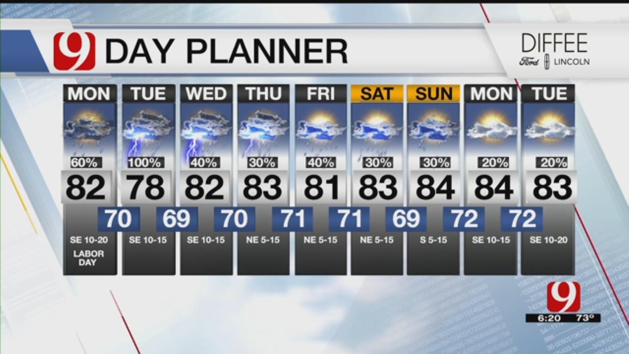
A warm start to your Labor Day but thunderstorm chances are expected to develop throughout the day.
Our unsettled weather pattern ramps up Monday as a weak tropical disturbance moves north through Texas while a second disturbance moves in from the southwest. These will bring a good chance of rain and storms to Oklahoma Monday afternoon and evening into the night.
Some heavy storms are likely with the possibility of one or two severe storms. Overall instability is lower than Sunday, so a cut-in or two will only be needed if a severe storm shows up.
Well, September is our 3rd wettest month of the year on average. A very unsettled pattern with lots of tropical moisture giving us plenty of rain chances over the next week. Rainfall 1-2", isolated 3"+ by Friday. #okwx @news9 @tornadopayne @themahler @CassieHeiter @laceyswope pic.twitter.com/PO0H3hXtCw
— Justin Rudicel (@ChasingtheMeso) September 3, 2018
The tropical moisture and jet stream will keep a good chance of rain and storms for Oklahoma all week and even into next weekend. The overall severe weather threat is low. Heavy rain and potential flooding will need to be monitored.
Happy Labor Day! Here's your OKC hour by hour forecast. Rain chances increase this afternoon/evening. #okwx @NEWS9 pic.twitter.com/h2z0oURFF5
— Lacey Swope (@LaceySwope) September 3, 2018
Rain chances in Oklahoma City increase after 3:00 p.m. going in Monday night. The severe weather threat looks very low but some heavy rainfall possible.
By this weekend, what's left of Tropical Storm Gordon may move into parts of southern and southeastern Oklahoma with more heavy rain. Overall temperature trend for this week is for highs to stay in the lower 80s with a couple of days possibly staying in the 70s!
A potential tropical storm is developing near the Bahamas. This will move over the warm Gulf waters and likely intensify. The remnants may make it to Oklahoma late this week. *IF* it makes it here, very heavy will be a result. Right now the highest impacts looks to be in SE OK. pic.twitter.com/LktTTHeLsn
— Lacey Swope (@LaceySwope) September 3, 2018
T.S. GORDON is still taking shape this morning. Notice the forecast paths start to really vary Thursday into Friday. This is NOT locked in to impact OK, but is something to watch for sure. If the remnants make it here, very heavy rain will be result. #okwx @NEWS9 pic.twitter.com/HAjWYcjO1y
— Lacey Swope (@LaceySwope) September 3, 2018
Thunderstorm chances will increase through Labor Day.
","affiliate":{"_id":"5cc353fe1c9d440000d3b70f","callSign":"kwtv","origin":"https://www.news9.com"},"contentClass":"weather","createdAt":"2020-01-31T20:04:03.204Z","updatedAt":"2022-03-30T21:17:13.856Z","__v":2,"show":true,"link":"/story/5e348833527dcf49dad7952e/rain-chances-increase-monday-afternoon-in-okc","hasSchedule":false,"id":"5e348833527dcf49dad7952e"};
Get The Daily Update!
Be among the first to get breaking news, weather, and general news updates from News 9 delivered right to your inbox!
More Like This

September 3rd, 2018

March 22nd, 2024

March 14th, 2024

February 9th, 2024
Top Headlines

May 4th, 2024

May 4th, 2024

May 4th, 2024
