Tulsa Weather: Cooler midweek break before more severe storms this weekend
A cold front brought cooler temperatures and a break from the storms for now.Wednesday, June 4th 2025, 6:34 pm
Thursday Outlook
Most of the storms Thursday will be located to the west of the area through most of the day. Early Thursday, a few showers or storms will be likely across western OK. Most of these should dive southeast along the Red River Valley and remain away from most of our immediate areas of concern.
A few spotty showers may still be possible, but the probability now remains low.

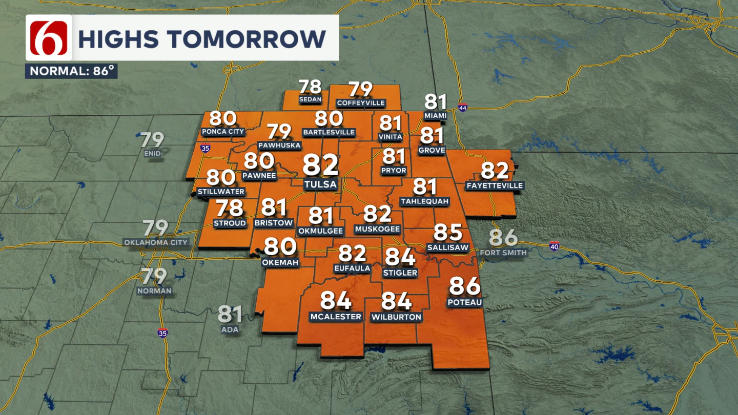
Morning lows will be in the 60s and highs reaching back into the lower to mid-80s as south winds return bringing low level moisture back into the area. This will set the stage for additional storms developing Thursday afternoon and evening
Friday Morning Storm Potential
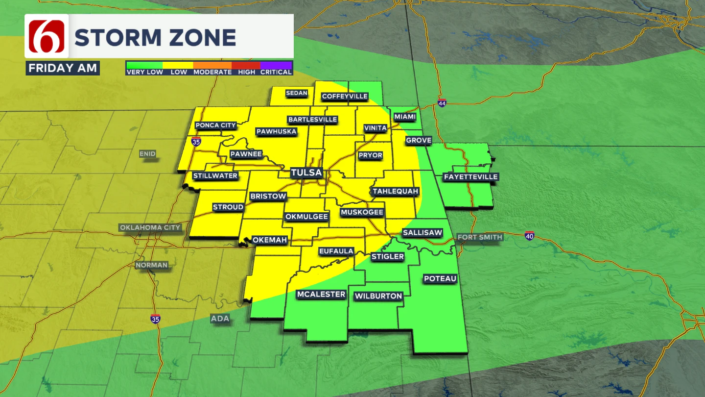
A surface ridge, combined with a mid-level ridge over south Texas and strong west-to-northwest flow across southern Kansas and northern Oklahoma, may support the development of a severe storm complex across New Mexico, Southeastern Colorado, and Southwestern Kansas that will eventually have impacts across part of northern Oklahoma late Thursday night into Friday morning.

Friday morning will begin with lows in the mid-to-upper 60s and warm to highs in the lower 80s. This pattern is expected to continue into the weekend, although the exact track of Thursday night’s storms will influence how weekend systems evolve.
Weekend Outlook
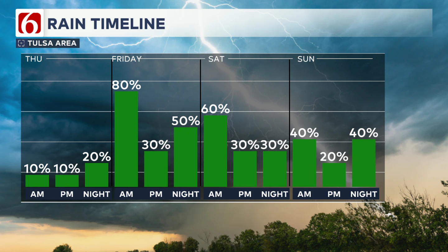
Despite some uncertainty in the storm track, the setup continues to favor late-night and early-morning storm activity. Complexes of storms are possible from Friday night into Saturday morning, and again from Saturday night into early Sunday.

Any of these could bring damaging winds and heavy rainfall. By late Saturday night into Sunday, the frontal boundary will likely shift farther south, focusing storm activity over southern Oklahoma.
Weekend temperatures will feature lows in the mid-to-upper 60s and highs in the low to mid-80s.
Early Next Week
The active pattern is expected to continue into early next week, with morning lows in the mid-60s and afternoon highs in the mid-80s on both Monday and Tuesday. A complex of storms will be possible late Sunday night into Monday morning across southeastern Kansas and northern Oklahoma.
The Morning Weather Podcast:
The daily morning weather podcast briefing will remain on hold indefinitely due to ongoing internal workflow issues.
We're working to resolve these challenges as soon as possible and appreciate your patience. We apologize for the inconvenience and hope to be back soon. Thank you for your understanding.
Need-to-know severe Oklahoma weather prep:
🔗Severe weather safety: what you need to know to prepare
🔗Tornado Watch vs. Tornado Warning: what they mean and what to do
🔗Severe weather safety: what to do before, during, and after a storm
🔗Why registering your storm shelter in Oklahoma could save your life
🔗Floodwater kills more Oklahomans than tornadoes in the last decade, here's why
🔗'Turn around, don't drown': Flood safety tips for Oklahomans
🔗5 things to know: How Oklahomans can get federal money to install storm shelters
🔗Breaking down the SoonerSafe Rebate Program: Do I qualify for a storm shelter?
Hot weather safety:
🔗Oklahoma heat safety tips: How to spot and prevent heat illness
Watch us on YouTube
Follow NewsOn6 on X/Twitter for automated severe weather alert posts: @NewsOn6
Emergency Info: Outages Across Oklahoma:
Northeast Oklahoma has various power companies and electric cooperatives, many of which have overlapping areas of coverage. Below is a link to various outage maps.
- PSO Outage Map
- OG&E Outage Map
- VVEC Outage Map
- Indian Electric Cooperative (IEC) Outage Map
- Oklahoma Association of Electric Cooperatives Outage Map — (Note: Several Smaller Co-ops Included)
Follow News On 6 Meteorologists on Facebook
More Like This
June 4th, 2025
June 4th, 2025
Top Headlines
June 4th, 2025


