Overnight Flash Flood Warning Issued For Counties In Green Country
Severe weather threats return to Green Country on Thursday.Thursday, March 23rd 2023, 10:42 pm


Flash Flood Warnings were issued for several counties Thursday, as well as Severe Thunderstorm Warnings.
Flash Flood Warning for Creek, Rogers, Tulsa and Wagoner County in OK until 2:45am Friday.
Flash Flood Warning for Delaware, Mayes, and Rogers County in OK until 4:15am Friday.
TULSA, Okla. - Severe weather threats return to Green Country around 2 p.m. on Thursday.
Here are the details from News On 6 Meteorologists
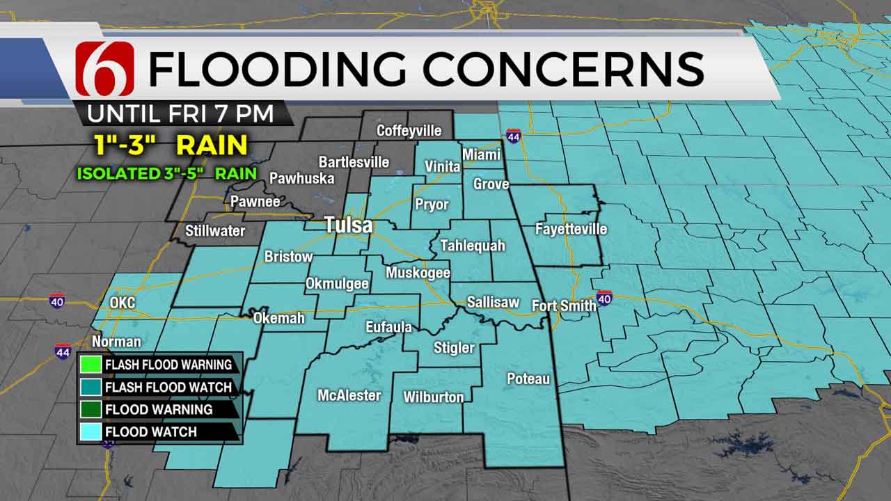
The overall appearance of the incoming upper-level system seems to be slower with each model run yet the progression of the surface cold front is slightly faster, arriving midday to early afternoon. A flood watch has been posted across part of the area where one to three inches will be common, and some outliers from four to near-five inches of rain will be possible.
Severe weather threats will also remain this afternoon and Thursday night and could linger slightly longer into part of early Friday morning to midday before exiting eastward. Our forecast already was positioned for a longer period of rain Friday morning to midday before ending, but we'll make a few adjustments, nonetheless.
Most of the weekend should be fine despite another fast-developing system that brings a low chance for a shower near or north of the area Sunday. As the Sunday system moves east, a surface cold front drops southward bringing cool and stable air early next week before our next stronger system arrives for the latter half of the week.

The strong southerly flow will remain Thursday morning with low-level dew points in the 60s through the area. Temps will start in the 60s and reach the lower 70s north and mid to upper 70s south for the max for the day. The surface cold front will enter northern OK this morning and move slightly south of the metro around noon to 2 p.m. before stalling or slowing down significantly for a few hours this evening. This creates a broad and tricky range of afternoon temps, with some locations across northern OK dropping into the 50s and 60s, while south of the boundary remains in the 70s.

As the main upper-level low remains west, a series of waves will proceed the trough and begin to initiate thunderstorms this afternoon near and north of the surface front. Severe parameters suggest the main threat will be large hail and damaging winds along with heavy rainfall threats, as these storms should be mostly elevated. A non-zero tornado threat will exist despite the upper air flow parallel to the surface boundary if any updraft can latch onto the warm side of the boundary.
As storms develop into the evening hours, the front will slowly sag more southeast with additional storms attempting to develop on both sides of the boundary. Cells north of the front should continue to be elevated and mostly a hail threat, but storms south of the boundary will support all modes of severe weather. Pre-dawn Friday into midmorning, far southeastern OK into extreme east-central OK will still be in the warm sector of the system where severe weather will remain possible before moving out of the area by midday.
Locations behind the front Friday will experience gusty north winds from 15 to 25 mph along with morning lows in the mid-40s and afternoon highs in the mid-50s.
Saturday morning starts in the upper 30s and lower 40s with daytime highs in the 60s with light and variable wind. Gusty south winds return Sunday from 15 to 30 mph with highs in the upper 60s and lower 70s. Highs will remain in the mid to upper 50s early next week before warming for the latter half of the period as a strong storm system nears the state.

Thanks for reading the Thursday morning weather discussion and blog.
Please remain aware of your weather surroundings this afternoon. tonight, overnight, and into early Friday morning.
Have a super great day! If you’re into podcasts or in a rush, check out my daily weather update. Search for NewsOn6 and ‘Weather Out The Door’ on most podcast providers, including Spotify, Stitcher and Tune-In, or Click Here to listen on Apple Podcasts.

Get The Daily Update!
Be among the first to get breaking news, weather, and general news updates from News 9 delivered right to your inbox!
More Like This
March 23rd, 2023


May 16th, 2024

May 16th, 2024
Top Headlines


May 16th, 2024

May 16th, 2024
