Winter Storm Could Bring Freezing Rain, Snow This Weekend
<p>Highs on this Christmas Eve will rebound into the mid 50s today, and we're in for mid 60s on Christmas Day.</p>Thursday, December 24th 2015, 9:47 am


Highs on this Christmas Eve will rebound into the mid 50s today, and we're in for mid 60s on Christmas Day.
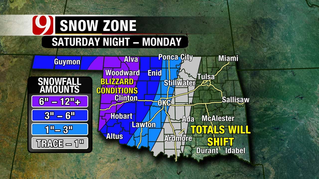
Our winter storm/blizzard begins on Saturday with heavy rain lifting in. Could even see a few strong to severe storms in SE OK from Durant to Ada to Sallisaw.
Cold rain on Saturday will transition to freezing rain to sleet to snow on Sunday. Here's a look at the timing of the freezing line at the surface to give you a better idea at when winter precip could start in your area. Current track of the storm and timing will bring at least a glaze of freezing rain to central OK, and then quite a bit of sleet as deeper freezing air moves in.
Remember, if sleet holds off, ice totals will be higher. If sleet lasts longer, snow totals will be less. All precip totals will be determined by how long it takes the deep layer of cold air to arrive and this is NOT locked in.
Wind gusts to at least 55 mph will mean blizzard conditions out west. This could also bring down tree limbs, and power lines along and west of I-35. Travel is expected to become very difficult if not impossible this weekend.
You still have to stay tuned to the forecast as it evolves. Confidence in totals will go up this evening and tomorrow morning as the actual storm moves over land. Right now it is still over the ocean.
Stay with News 9, we'll keep you advised.

Get The Daily Update!
Be among the first to get breaking news, weather, and general news updates from News 9 delivered right to your inbox!
More Like This
December 24th, 2015

March 22nd, 2024

March 14th, 2024

February 9th, 2024
Top Headlines

May 10th, 2024