Fall Weather Slowly Arriving
More warm temperatures are expected on Wednesday, but a fall front could soon arrive.Wednesday, October 5th 2022, 6:03 am
TULSA, Okla. -
More warm temperatures are expected on Wednesday, but a fall front could soon arrive.
Here are the details from News On 6 Meteorologist Alan Crone:

The first of three systems will slowly influence part of the state on Wednesday with increasing clouds, and even a small window for a brief shower or sprinkle across part of Northern Oklahoma. The chance for measurable precipitation remains extremely low but just enough to mention for a few locations. Winds should remain from the southwest for most of the morning but slowly veer from the northwest later Wednesday afternoon and night with relatively light speed. An ozone alert will be underway today near and surrounding the Tulsa metropolitan area. Ozone formation in the upper levels of the atmosphere is beneficial, but formation near the ground can be harmful to those who suffer from significant respiratory issues.

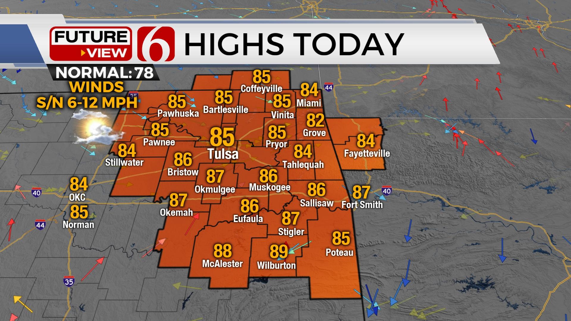
Temperatures today will stay in the lower to mid-80s along the far northern Oklahoma and southern Kansas region, mid 80s near the metro, and upper 80s across far southern Oklahoma. Thursday morning starts in the mid-50s with north winds at 10 to 15 mph throughout the day. Afternoon highs tomorrow will range in the lower to mid-80s north and upper 80s south. Tomorrow may be one of the last relatively warm days for the near-term future.
It appears our pattern is finally changing, and the long-awaited return of true fall weather will slowly be arriving. Our stronger fall front in our current series of systems should be arriving early Friday morning. A stout upper-level system will drop across the southern prairie provinces of Canada into the upper Midwest. Behind this, a stout surface ridge of high pressure develops across part of Canada and brings cooler weather southbound.
While most of the true colder weather stays north, we will see a decent return of fall-like conditions Friday and Saturday. Friday's daytime highs will range in the lower 70s north and upper 70 south. Saturday morning starts chilly with lows in the mid-40s near Tulsa and in the lower 40s in the valleys of Eastern Oklahoma. Afternoon highs Saturday may stay in the upper 60s and lower 70s across the northern third of the state and into the mid-70s across southeastern Oklahoma.

The pattern will present an opportunity for scattered showers developing to our west early this weekend and could influence part of our area Sunday and Monday. Additionally, the potential for additional showers or even thunderstorms will arrive early next week ahead of yet another fall front.
Thanks for reading the Wednesday morning weather discussion and blog.
Alan Crone
KOTV
If you’re into podcasts, check out my daily weather update. Search for NewsOn6 and ‘Weather Out The Door’ on most podcast providers, including Spotify, Stitcher and Tune-In, or Click Here to listen on Apple Podcasts.

Get The Daily Update!
Be among the first to get breaking news, weather, and general news updates from News 9 delivered right to your inbox!
More Like This
October 5th, 2022

April 16th, 2024

April 16th, 2024

April 16th, 2024
Top Headlines

April 16th, 2024

April 16th, 2024

April 16th, 2024
