A Pattern Change Expected Soon, Showers Headed Out
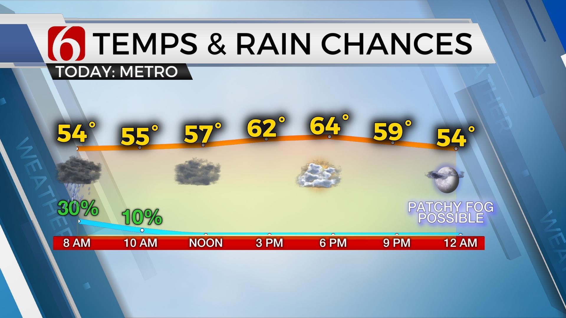
The slow-moving upper level low, partly responsible for our wet and cool weather will finally move far enough east today taking the showers away from our area.Thursday, May 26th 2022, 5:24 am
TULSA, Oklahoma -
The slow-moving upper level low, partly responsible for our wet and cool weather will finally move far enough east today taking the showers away from our area.
The clouds will slowly clear later from the west to east, but the latest timing suggests another mostly cloudy and cool afternoon near and east of Tulsa, with highs in lower 60s.
Some sunshine is possible across the far western areas with highs near the lower 70s.
A mid-level ridge of high pressure should be the dominant upper feature this weekend before the next trough influences our weather with storms chances returning by the middle of next week.
Pesky showers are again up and running Thursday morning under and east of the upper level low. Most of this activity will quickly move east early in the morning.
A few small showers may redevelop across extreme northeast Oklahoma Thursday afternoon. Northwest winds from 15-25 mph are likely with drier air slowly filtering into the area.
This will bring Friday morning temps down into the upper 40s and lower 50s, followed by sunshine and highs reaching the upper 70s to lower 80s with west winds near 10-15 mph. A weekend warm-up is likely.
A surface low will deepen across the high plains this weekend resulting in strong southerly flow from 20-30 mph as low-level moisture streams into the region.
This will gradually increase the heat index values Sunday and early next week with actual temps nearing the upper 80s to lower 90s.
The only wrinkle this weekend continues in the GFS model, bringing a small disturbance across the state Saturday that could trigger a few scattered showers or storms. This is mostly an outlier when compared to other data.
I've continued to keep this low-end chance out of the forecast but will watch closely if we need to add a low chance Saturday morning.
The next stronger system nears by the middle of next week with increasing thunder chances Tuesday evening into Wednesday.


Get The Daily Update!
Be among the first to get breaking news, weather, and general news updates from News 9 delivered right to your inbox!
More Like This
May 26th, 2022


April 19th, 2024
April 19th, 2024
Top Headlines


April 19th, 2024

April 19th, 2024