Sunny Skies, Light Winds
Sunny skies and some light winds are expected on Tuesday morning, but shower chances could return to Green Country toward the end of the week.Tuesday, April 26th 2022, 6:04 am
TULSA, Oklahoma -
Sunny skies and some light winds are expected on Tuesday morning, but shower chances could return to Green Country toward the end of the week.
Here are the details from News On 6 Meteorologist Alan Crone:

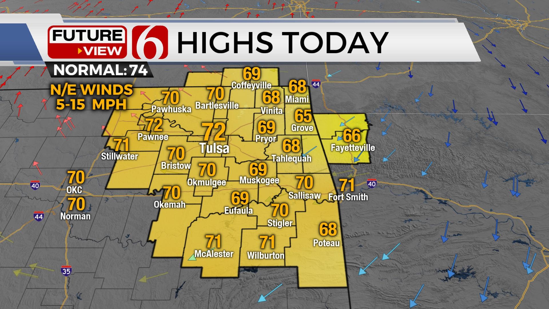
A surface ridge of high pressure will nudge into northeastern Oklahoma on Tuesday morning, bringing clear sky, light winds and dry air across the area. This will allow temps to drop into the upper 30s in a few valleys with lower to mid-40s from the metro southward. We expect sunshine on Tuesday with afternoon highs in the upper 60s to lower 70s. Winds will be relatively light for most of the day. South winds return Wednesday and will increase speeds through the rest of the week in advance of several storm chances across the state. The first arrives early Thursday morning, the second Thursday evening late into Friday morning, and the third Friday evening into pre-dawn Saturday. A few strong to severe storms will be possible with this pattern. Most of the severe threat will be west of the region Wednesday and Thursday. The late-week system currently appears to have some severe weather threats as a stronger upper-level system nears the state and a dry line forms across or near the I-35 region. Once again, severe weather threats may be highly conditional Friday afternoon and evening as a layer of warm air aloft could suppress or limit storm development. If storms form, all modes of severe weather will exist.

The upper air flow brings a fast and relatively weak wave across the area Wednesday night into Thursday morning. Low-level moisture will be flowing into this system, but surface instability and upper-level support will be greater to the west and mostly lacking for any severe weather threats across NE OK. The 2nd wave nearing Thursday evening may have slightly more dynamic energy, but the Friday system appears to have much stronger upper-level wind flow combined with surface moisture and instability. The pattern supports the mention for strong and severe storm formation. A front should pass the metro either late Friday evening or Saturday morning giving southeastern OK a low chance for storms Saturday afternoon. The boundary is expected to retreat northward Sunday as a warm front brings additional storm chances across the area into early next week. A typical spring pattern across the southern plains.

Thanks for reading the Tuesday morning weather discussion and blog.
Have a super great day!
Alan Crone
KOTV
If you’re into podcasts, check out my daily weather update. Search for NewsOn6 and ‘Weather Out The Door’ on most podcast providers, including Spotify, Stitcher and Tune-In, or Click Here to listen on Apple Podcasts.

Get The Daily Update!
Be among the first to get breaking news, weather, and general news updates from News 9 delivered right to your inbox!
More Like This
April 26th, 2022

April 18th, 2024
April 18th, 2024

April 18th, 2024
Top Headlines

April 18th, 2024

April 18th, 2024

April 18th, 2024

