Shower Chances Return To Green Country
Gusty winds and shower chances return to Green Country on Tuesday.Tuesday, April 19th 2022, 7:13 am
TULSA, Oklahoma -
Gusty winds and shower chances return to Green Country on Tuesday.
Here are the details from News On 6 Meteorologist Alan Crone:

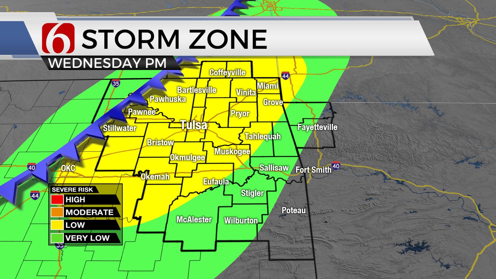
Mostly clear sky and dry air has allowed temperatures to drop into the upper 30s in the valleys of Eastern OK with locations south of I-40 in the lower 40s. We'll expect highs reaching the upper 60s to lower 70s across the area today along with increasing southeast winds from 15 to near 30 mph. Low level moisture will stream northward this afternoon reaching the area this evening and overnight. LaterTuesday, the first in a series of upper-level waves will move from the west to east bringing a slight chance of showers into Eastern OK by the afternoon. A better push of energy arrives tonight and exits early Wednesday morning as better low-level moisture arrives. This will result in increasing showers later Tuesday night into early Wednesday morning moving from the west to east. Enough instability will exist for some thunder. Severe weather is not expected.

As the first wave exits into Arkansas midday, clouds are expected to clear from the west to east allowing a period of afternoon heating with temps moving into the mid to upper 70s in Eastern OK and much warmer temperatures in western OK. A cold front will enter far northern OK Wednesday evening. A small window will occur for strong and severe storm development as the front nears the I-44 region. If sufficient heating can occur, low level moisture streaming into the system combined with strong and persistent deep layer shear will support all modes of severe storm formation for a few hours Wednesday night. The front will near the metro and stall overnight before quickly lifting northward Thursday morning. A small window will also remain for storms near and north of this warm front Thursday morning before quickly moving into the Missouri Valley. A few of these early Thursday morning storms may produce some nickel hail along the OK-Kansas state line before racing into the Missouri Valley.

The rest of the week features strong south winds and warmer weather with afternoon highs reaching the lower 80s. The upper air flow returns from the southwest this weekend with a dry line establishing across far western OK and another front nearing the state. This brings a few rounds of storms into the region, including severe weather mentions. We'll have more specifics about the weekend tomorrow, but low chances will continue Saturday with higher chances Sunday.
Thanks for reading the Tuesday morning weather discussion and blog.
Have a super great day!
Alan Crone
KOTV
If you’re into podcasts, check out my daily weather update. Search for NewsOn6 and ‘Weather Out The Door’ on most podcast providers, including Spotify, Stitcher and Tune-In, or Click Here to listen on Apple Podcasts.

Get The Daily Update!
Be among the first to get breaking news, weather, and general news updates from News 9 delivered right to your inbox!
More Like This
April 19th, 2022
April 18th, 2024

April 18th, 2024

April 18th, 2024
Top Headlines


April 18th, 2024
April 18th, 2024

April 18th, 2024
