Bouts Of Rain, Storms Expected, Highs In The Upper 70s
Bouts of rain and storms are expected for the next several days.Monday, May 17th 2021, 6:52 am
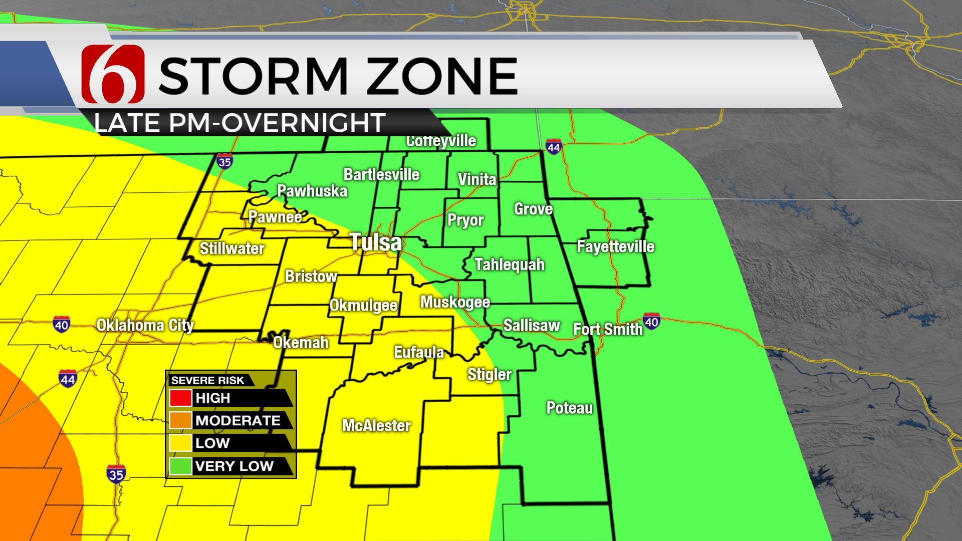
The upper air pattern continues with a persistent trough to our west and a midlevel ridge to the east. This places most of the state in a favorable position for occasional bouts of rain and storms for the next several days. But this does not mean it will rain every hour of every day in every location across Eastern OK. We've had plenty of dry times this past weekend and these pockets of dry times and spaces will also remain periodically through the next few days, including part of today. This means our probabilities must remain high for the next few days, but there will be time periods of each day that will be dry. In some cases, decent stretches of dry times versus the wet ones. This will be the case today near the metro region. We’ll keep a chance for a few showers or storms, but most of the region will remain dry from midday trough the afternoon before higher chances arrive late tonight into early Tuesday morning. This pattern will present the chance for some flooding rains and issues, including mainline river and stream flooding. We feel that flood watches will eventually be required for part of the area soon. As of this post, flood watches are underway from Stillwater southward to the Red River through Thursday morning. A few counties across southeastern will be under flood watches beginning tomorrow through Thursday morning, but no counties across northeastern OK are currently under a flood watch. This may change later.

One batch of shower activity is exiting across part of the area this morning. As it clears, we're probably going to have periods of dry weather today highs reaching the upper 70s to near 80. Outflow boundaries from this morning's activity will play a big role of where some heavier thunderstorms will attempt to develop overnight and into early Tuesday as the main trough currently west begins moving closer to the state. But the influence of this trough will also bring increasing thunderstorm chances for larger parts of Eastern OK tonight continuing through Wednesday. Basically, Tuesday and Wednesday should represent both the higher chances and heavier rainfall threats for most of our area, especially during the late night and overnight positions. The upper air flow is relatively weak for this time of year, but some strong to severe storms will be possible for eastern OK with higher severe weather probabilities near and west of the area today, but closer to our region Tuesday.

Thursday into Friday the mid-level ridge to our east may briefly expand and slightly strengthen. This may create more of a meridional or south to north flow. Another disturbance to our west will continue to generate showers and thunder daily, but the higher probability could easily remain west of our location Friday into the weekend, but there will be decent chances through Thursday at this point before we begin to lower chances some Friday into the weekend.

Temps for the next few days will remain highly consistent with lows in the mid-60s and highs in the upper 70s near 80. Low level moisture content is high, and humid conditions are also likely.
Thanks for reading the Monday morning weather discussion and blog.
Have a super great day!
Alan Crone
KOTV
If you’re into podcasts, check out my daily weather update below. Search for NewsOn6 and ‘Weather Out The Door’ on most podcast providers, including Apple, Stitcher, Tune-In and below on Spotify.


Get The Daily Update!
Be among the first to get breaking news, weather, and general news updates from News 9 delivered right to your inbox!
More Like This
May 17th, 2021

April 19th, 2024

April 19th, 2024

April 19th, 2024
Top Headlines

April 19th, 2024

April 19th, 2024

April 19th, 2024

April 19th, 2024
