Severe Weather Moves Across Oklahoma Saturday Evening, Overnight
The weekend is here and severe weather chances are going up for Oklahoma.Saturday, April 26th 2014, 9:03 am
The weekend is here and severe weather chances are going up for Oklahoma.
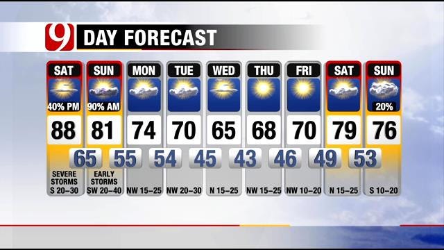
The morning and afternoon look great for central Oklahoma. Warm, humid and breezy. Clouds increase this afternoon.
The risk for severe storms will increase late this afternoon around 5 p.m., mainly along I-40 south to the Red River. The primary threats will be large hail and damaging winds, but a few tornadoes can't be ruled out. If they do form, again, western and southwestern Oklahoma will be the most likely area.
The threat for severe weather will move east after 10 p.m. into central Oklahoma with primarily a hail and wind threat. The tornado threat will decrease into the overnight as the storms move east. It could be bumpy overnight as the storms move into the area.
If you're running in the Memorial Marathon tomorrow morning, it looks stormy for the beginning of the race. Rain chances will gradually drop as the morning progresses.
Stay with News 9 for all the latest developments on today's severe weather threat.
More Like This
April 26th, 2014
March 22nd, 2024
March 14th, 2024
February 9th, 2024
Top Headlines
April 19th, 2024


