Strong Winds Wednesday As Storm Develops Out West
<p>A powerful storm will develop this weekend! Before it does, we will have some action in the form of wind and a few storms. </p>Wednesday, October 3rd 2018, 6:44 am


A powerful storm will develop this weekend!
Before it does, we will have some action in the form of wind and a few storms. Wednesday will be very windy with south winds ranging from 15-30 mph. A cool front is expected to line up near the Kansas border late Wednesday then move into the far north and northwest parts of the state on Thursday.
Summertime heat takes hold today. Tonight a cold front will move into northern OK. Rain/t-storms possible along the boundary. #okwx @NEWS9 pic.twitter.com/INDnjxU3nb
— Lacey Swope (@LaceySwope) October 3, 2018
As it does, some rain will be possible north Thursday morning and a few storms northwest Thursday evening. Storm chances will increase in the northwest on Friday then move into the state Saturday.
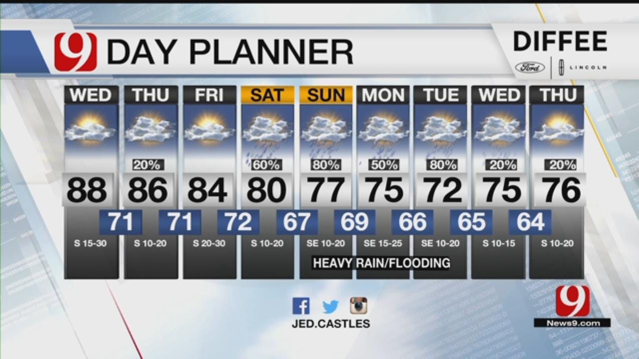
9 DAY: The pattern is changing! Winds will be cranked up the next 6-7 days as a big storm develops to our west. This will bring steady to likely chances for rain and storms starting Saturday. Scattered storms expected N & NW Thurs & Friday.@news9 #okwx pic.twitter.com/2RUkFBWaAa
— Jed Castles News 9 (@JedCastles) October 3, 2018
The areas of rain and storms will continue across the state through next Wednesday before ending. Much of this rain system will produce heavy rain totals.
Most areas are showing 2-5 inches of rainfall with some higher totals expected. Record rainfall will be possible. The highest totals as of now look to be west of I-35.
As strong as this storm is, some severe weather will be possible. Some severe weather looks possible late Thursday in the northwest. Cool and wet behind the front and warm, humid and wet ahead of it!
As it does, some rain will be possible north Thursday morning and a few storms northwest Thursday evening. Storm chances will increase in the northwest on Friday then move into the state Saturday.
9 DAY: The pattern is changing! Winds will be cranked up the next 6-7 days as a big storm develops to our west. This will bring steady to likely chances for rain and storms starting Saturday. Scattered storms expected N & NW Thurs & Friday.@news9 #okwx pic.twitter.com/2RUkFBWaAa
— Jed Castles News 9 (@JedCastles) October 3, 2018
The areas of rain and storms will continue across the state through next Wednesday before ending. Much of this rain system will produce heavy rain totals.
Most areas are showing 2-5 inches of rainfall with some higher totals expected. Record rainfall will be possible. The highest totals as of now look to be west of I-35.
As strong as this storm is, some severe weather will be possible. Some severe weather looks possible late Thursday in the northwest. Cool and wet behind the front and warm, humid and wet ahead of it!
","published":"2018-10-03T11:44:25.000Z","updated":"2018-10-03T12:36:19.000Z","summary":"A powerful storm will develop this weekend! Before it does, we will have some action in the form of wind and a few storms.
","affiliate":{"_id":"5cc353fe1c9d440000d3b70f","callSign":"kwtv","origin":"https://www.news9.com"},"contentClass":"weather","createdAt":"2020-01-31T19:57:35.007Z","updatedAt":"2022-03-30T21:13:40.094Z","__v":2,"show":true,"link":"/story/5e3486af527dcf49dad78875/strong-winds-wednesday-as-storm-develops-out-west","hasSchedule":false,"id":"5e3486af527dcf49dad78875"};
Get The Daily Update!
Be among the first to get breaking news, weather, and general news updates from News 9 delivered right to your inbox!
More Like This

October 3rd, 2018

March 22nd, 2024

March 14th, 2024

February 9th, 2024
Top Headlines

April 19th, 2024

April 19th, 2024

April 19th, 2024

