Australian Bushfires Are Creating 'Pyrocumulonimbus' Thunderstorms That Can Start More Fires
The brushfires in Australia are growing and have become so massive and powerful that they're creating their own dangerous weather phenomenon. It happens through the formation of "pyrocumulonimbus" clouds — what NASA calls "the fire-breathing dragonTuesday, December 31st 2019, 10:51 am

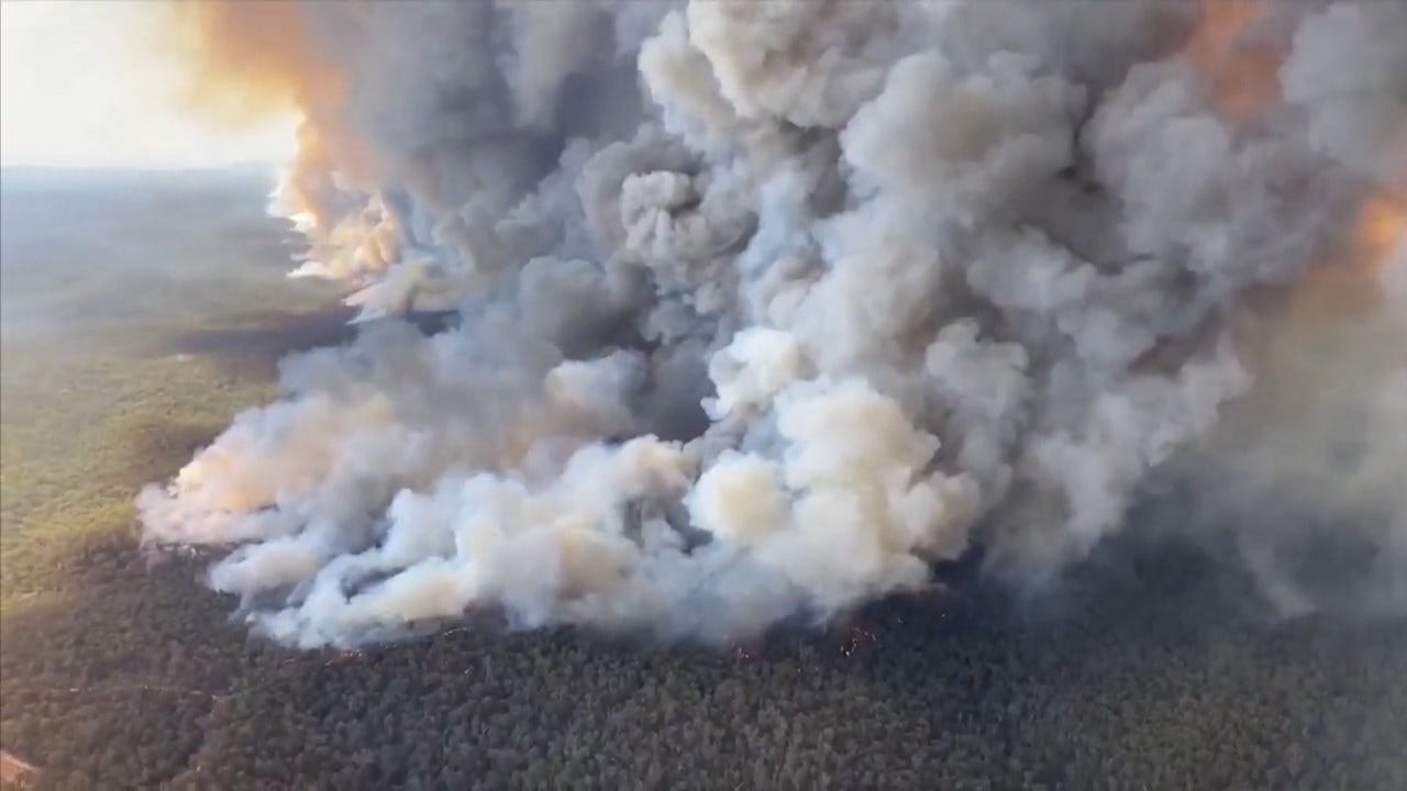
The brushfires in Australia are growing and have become so massive and powerful that they're creating their own dangerous weather phenomenon. It happens through the formation of "pyrocumulonimbus" clouds — what NASA calls "the fire-breathing dragon of clouds." These fire-induced storms bring little rain but are packed with lightning that can spark new fires. A weather alert on Monday forecast the thunderstorms over the southern Australian province of Victoria.
"Pyro-cumulonimbus clouds have developed to altitudes over 16km in East #Gippsland this afternoon. These fire-induced storms can spread fires through lightning, lofting of embers and generation of severe wind outflows #VicWeather #VicFires" the Bureau of Meteorology in Victoria tweeted.
According to the BBC, about 30,000 residents and tourists were urged to flee East Gippsland until evacuations were deemed too risky when fires reached major roads. Fires caused by pyrocumulonimbus storms were also recorded in New South Wales, the province where Sydney is located.
Australia has been battling scorching temperatures and out-of-control brushfires throughout the country, both conditions that increase the risk for pyrocumulonimbus clouds — also known as "fire clouds" or flammagenitus.
CBS News meteorologist Jeff Berardelli explained the weather phenomenon could be on the rise as the globe wrestles with climate change.
"It makes sense that as the air and ground warms and drys due to human-caused climate change, fires will become larger, burn longer and hotter," Berardelli said. "Therefore, theoretically, pyrocumulonimbus clouds may become more common leading to more erratic fire behavior and more rapid fire spread."
What are pyrocumulonimbus thunderstorms?
Pyrocumulonimbus are very similar to typical thunderstorms, with a "couple of key differences," according to Berardelli. Both are created through rapidly rising air caused by heating of the air column.
"In the case of pyrocumulonimbus, the fire itself heats the air so intensely it fuels rapidly rising motion above the fire, like the updrafts in thunderstorms, which can reach speeds over 100 miles per hour," Berardeli said. "That propels smoke and ash several miles into the atmosphere where the air cools and the available water vapor condenses into visible clouds."
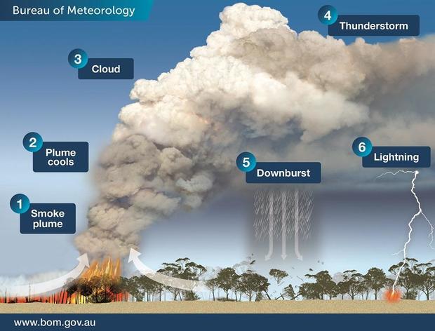
The ash then helps condense the water vapor into droplets by acting as condensation nuclei — dust for the moisture to cling onto. Berardelli said the more intense the fires, the more intense the updrafts and the greater potential for these clouds to grow upward vertically to miles high.
"The faster this process takes place the more likely the clouds are to spark lightning, just like real thunderstorms," Berardelli said. "But the difference is that unlike real thunderstorms, the rain that falls is evaporated by the heat and dryness of the fire before it can reach the ground. This is a dangerous side effect, because pyrocumulonimbus do not produce rain to help put out fires but they do spark lightning which can ignite new fires."
Australia has been ravaged by fires since September. About 12.35 million acres have burned nationwide, Ten people, including a volunteer firefighter, have died and more than 1,000 homes have been destroyed.
First published on December 30, 2019 / 2:44 PM
© 2019 CBS Interactive Inc. All Rights Reserved.
undefined
According to the BBC, about 30,000 residents and tourists were urged to flee East Gippsland until evacuations were deemed too risky when fires reached major roads. Fires caused by pyrocumulonimbus storms were also recorded in New South Wales, the province where Sydney is located.
Australia has been battling scorching temperatures and out-of-control brushfires throughout the country, both conditions that increase the risk for pyrocumulonimbus clouds — also known as \"fire clouds\" or flammagenitus.
CBS News meteorologist Jeff Berardelli explained the weather phenomenon could be on the rise as the globe wrestles with climate change.
\"It makes sense that as the air and ground warms and drys due to human-caused climate change, fires will become larger, burn longer and hotter,\" Berardelli said. \"Therefore, theoretically, pyrocumulonimbus clouds may become more common leading to more erratic fire behavior and more rapid fire spread.\"
What are pyrocumulonimbus thunderstorms?
Pyrocumulonimbus are very similar to typical thunderstorms, with a \"couple of key differences,\" according to Berardelli. Both are created through rapidly rising air caused by heating of the air column.
\"In the case of pyrocumulonimbus, the fire itself heats the air so intensely it fuels rapidly rising motion above the fire, like the updrafts in thunderstorms, which can reach speeds over 100 miles per hour,\" Berardeli said. \"That propels smoke and ash several miles into the atmosphere where the air cools and the available water vapor condenses into visible clouds.\"

The ash then helps condense the water vapor into droplets by acting as condensation nuclei — dust for the moisture to cling onto. Berardelli said the more intense the fires, the more intense the updrafts and the greater potential for these clouds to grow upward vertically to miles high.
\"The faster this process takes place the more likely the clouds are to spark lightning, just like real thunderstorms,\" Berardelli said. \"But the difference is that unlike real thunderstorms, the rain that falls is evaporated by the heat and dryness of the fire before it can reach the ground. This is a dangerous side effect, because pyrocumulonimbus do not produce rain to help put out fires but they do spark lightning which can ignite new fires.\"
Australia has been ravaged by fires since September. About 12.35 million acres have burned nationwide, Ten people, including a volunteer firefighter, have died and more than 1,000 homes have been destroyed.
First published on December 30, 2019 / 2:44 PM
© 2019 CBS Interactive Inc. All Rights Reserved.
","published":"2019-12-31T16:51:22.000Z","updated":"2019-12-31T16:52:59.000Z","summary":"The brushfires in Australia are growing and have become so massive and powerful that they're creating their own dangerous weather phenomenon. It happens through the formation of \"pyrocumulonimbus\" clouds — what NASA calls \"the fire-breathing dragon","affiliate":{"_id":"5cc353fe1c9d440000d3b70f","callSign":"kwtv","origin":"https://www.news9.com"},"contentClass":"news","createdAt":"2020-01-31T17:58:06.291Z","updatedAt":"2022-03-30T20:07:04.535Z","__v":2,"show":true,"link":"/story/5e346aae527dcf49dad6c6c9/australian-bushfires-are-creating-pyrocumulonimbus-thunderstorms-that-can-start-more-fires","hasSchedule":false,"id":"5e346aae527dcf49dad6c6c9"};

Get The Daily Update!
Be among the first to get breaking news, weather, and general news updates from News 9 delivered right to your inbox!
More Like This

December 31st, 2019

March 22nd, 2024

March 14th, 2024

February 9th, 2024
Top Headlines

April 23rd, 2024

April 23rd, 2024

April 23rd, 2024

April 23rd, 2024
