Storms And Heavy Rain Monday And Tuesday With Flooding Expected
<p>Rain and storm chances will be likely Monday and especially Tuesday as a storm system moves in overhead. </p>Monday, October 8th 2018, 7:41 am


Rain and storm chances will settle in Monday and especially Tuesday as a storm system moves in overhead.
3-6 inches look possible, especially out west. The metro looks like 2-4 inches.
RAIN & STORM CHANCES THRU TUESDAY: Rain will be likely west and scattered across central OK today. Rain will become likely tonight with periods of rain and storms Tuesday. Heavy rain, some flooding and a few severe storms expected.@news9 #okwx pic.twitter.com/sxIgpyizEK
— Jed Castles News 9 (@JedCastles) October 8, 2018
Some flooding and some severe weather will continue to threaten the state. The rain and storms on Monday will start west in the morning then transition east into central Oklahoma during the day before ending.
Scattered showers and t-storms will develop through the day. Again today, a few storms may be severe with wind and flooding the main threat. There will be a very low tornado threat again today as well. Here's a look at the rain timeline for OKC. #okwx @NEWS9 pic.twitter.com/KLA9dU2mKA
— Lacey Swope (@LaceySwope) October 8, 2018
Some gusty winds and small hail is expected. The tornado threat is very low but not zero in southwest Oklahoma during the evening. The threat will increase again Tuesday as another bigger line of storms move across the state.
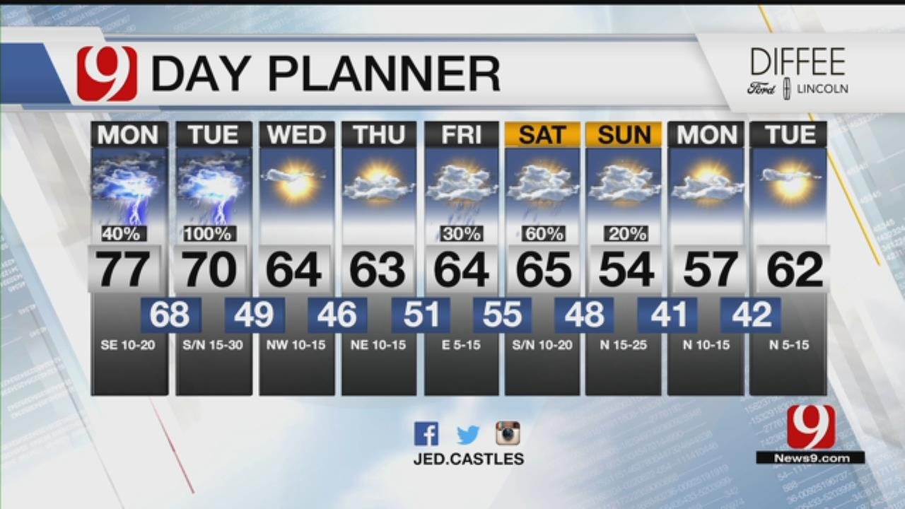
9 DAY: Rain and storms continue with flooding and some severe weather possible. Rain will end late Tuesday. Fall air pushes in and sets up over OK into next week! Lows could dip into the 30s by early next week.@news9 #okwx pic.twitter.com/O14J1YXQG3
— Jed Castles News 9 (@JedCastles) October 8, 2018
The rain will end from west to east behind the line and should be finished. It will end in the metro by late afternoon.
A strong cold front will push in Tuesday.
FORECAST UPDATE: The next 2 days you will need to stay weather aware! The rain and storms will stay mainly in west OK today. A strong cold front will push in Tuesday. Flooding and severe weather expected. All modes of severe weather look possible. @news9 #okwx pic.twitter.com/Fxv9CUiXAq
— Jed Castles News 9 (@JedCastles) October 8, 2018
Cooler, fall air moves in the rest of the week. Looks like Summer is over! Another storm system arrives later in the week around Friday.
FROSTY MORNINGS are just about a week away. Strongest cold front yet still looks to arrive this weekend. We could see freezing temperatures in our panhandle by early next week. Frosty AMs for N & NW OK Monday-Tuesday. Chilly conditions with low 40s in the OKC Metro. #okwx @NEWS9 pic.twitter.com/yBSsSeAgEF
— Lacey Swope (@LaceySwope) October 8, 2018
Some flooding and some severe weather will continue to threaten the state. The rain and storms on Monday will start west in the morning then transition east into central Oklahoma during the day before ending.
Scattered showers and t-storms will develop through the day. Again today, a few storms may be severe with wind and flooding the main threat. There will be a very low tornado threat again today as well. Here's a look at the rain timeline for OKC. #okwx @NEWS9 pic.twitter.com/KLA9dU2mKA
— Lacey Swope (@LaceySwope) October 8, 2018
Some gusty winds and small hail is expected. The tornado threat is very low but not zero in southwest Oklahoma during the evening. The threat will increase again Tuesday as another bigger line of storms move across the state.
9 DAY: Rain and storms continue with flooding and some severe weather possible. Rain will end late Tuesday. Fall air pushes in and sets up over OK into next week! Lows could dip into the 30s by early next week.@news9 #okwx pic.twitter.com/O14J1YXQG3
— Jed Castles News 9 (@JedCastles) October 8, 2018
The rain will end from west to east behind the line and should be finished. It will end in the metro by late afternoon.
A strong cold front will push in Tuesday.
FORECAST UPDATE: The next 2 days you will need to stay weather aware! The rain and storms will stay mainly in west OK today. A strong cold front will push in Tuesday. Flooding and severe weather expected. All modes of severe weather look possible. @news9 #okwx pic.twitter.com/Fxv9CUiXAq
— Jed Castles News 9 (@JedCastles) October 8, 2018
Cooler, fall air moves in the rest of the week. Looks like Summer is over! Another storm system arrives later in the week around Friday.
FROSTY MORNINGS are just about a week away. Strongest cold front yet still looks to arrive this weekend. We could see freezing temperatures in our panhandle by early next week. Frosty AMs for N & NW OK Monday-Tuesday. Chilly conditions with low 40s in the OKC Metro. #okwx @NEWS9 pic.twitter.com/yBSsSeAgEF
— Lacey Swope (@LaceySwope) October 8, 2018
Rain and storm chances will be likely Monday and especially Tuesday as a storm system moves in overhead.
","affiliate":{"_id":"5cc353fe1c9d440000d3b70f","callSign":"kwtv","origin":"https://www.news9.com"},"contentClass":"weather","createdAt":"2020-01-31T19:56:31.468Z","updatedAt":"2022-03-30T21:13:11.952Z","__v":2,"show":true,"link":"/story/5e34866f527dcf49dad78698/storms-and-heavy-rain-monday-and-tuesday-with-flooding-expected","hasSchedule":false,"id":"5e34866f527dcf49dad78698"};
Get The Daily Update!
Be among the first to get breaking news, weather, and general news updates from News 9 delivered right to your inbox!
More Like This

October 8th, 2018

March 22nd, 2024

March 14th, 2024

February 9th, 2024
Top Headlines


April 24th, 2024

April 24th, 2024

