Hot Thursday Afternoon: Stormy Pattern Moves Through Weekend
<p>No major changes to the ongoing forecast. Some rain expected across northern and central Oklahoma Thursday morning.</p>Thursday, October 4th 2018, 7:22 am

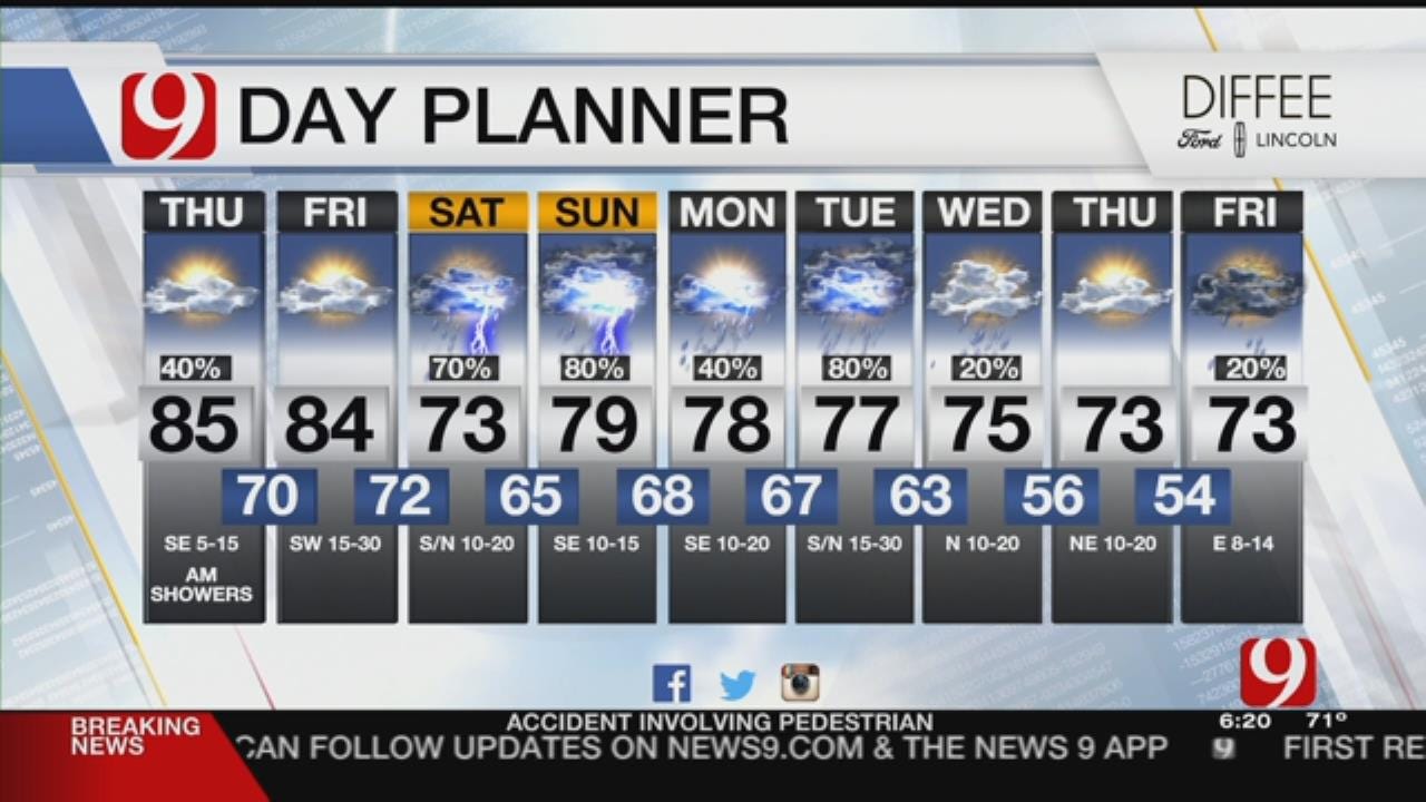
Some rain is expected across northern and central Oklahoma Thursday morning.
Warm and windy by Thursday afternoon. Storm chances will be possible across north and western Oklahoma during the afternoon and evening. A few storms could be severe with wind and hail the primary threats. The latest data has the storm chances low.
RECORD WARM LOWS in jeopardy this morning! Get ready for another hot day in the OKC metro. #okwx @NEWS9 pic.twitter.com/OOpq8JGh57
— Lacey Swope (@LaceySwope) October 4, 2018
A broad upper level trough will develop through the weekend.
9 DAY: A few showers this morning then dry and warm this afternoon. The pattern goes stormy starting Saturday. Rain and storms are expected thru Wednesday. Flooding and some severe weather expected!@news9 #okwx pic.twitter.com/lywcfoq17T
— Jed Castles News 9 (@JedCastles) October 4, 2018
This will produce a cold front that will slide into the state. Friday will see more storm chances in the northwest with a few being severe. Saturday will be more of a statewide chance.
FLOOD WATCH SATURDAY - WEDNESDAY: The threat for flooding will go up Saturday thru Wednesday as consecutive rain events move thru. Much of central and west OK expecting the heaviest totals.@news9 #okwx pic.twitter.com/9d0a0WZE12
— Jed Castles News 9 (@JedCastles) October 4, 2018
The storm will be a slow mover and bring the best rain chances Sunday through Tuesday. Heavy rainfall is expected and should lead to some flooding. Some severe weather is also possible.
The pattern will dry out some before another storm approaches late next week. More rain looks possible.
","published":"2018-10-04T12:22:34.000Z","updated":"2018-10-04T12:22:34.000Z","summary":"No major changes to the ongoing forecast. Some rain expected across northern and central Oklahoma Thursday morning.
","affiliate":{"_id":"5cc353fe1c9d440000d3b70f","callSign":"kwtv","origin":"https://www.news9.com"},"contentClass":"weather","createdAt":"2020-01-31T19:57:17.206Z","updatedAt":"2022-03-30T21:13:32.638Z","__v":2,"show":true,"link":"/story/5e34869d527dcf49dad787ec/hot-thursday-afternoon:-stormy-pattern-moves-through-weekend","hasSchedule":false,"id":"5e34869d527dcf49dad787ec"};
Get The Daily Update!
Be among the first to get breaking news, weather, and general news updates from News 9 delivered right to your inbox!
More Like This

October 4th, 2018

March 22nd, 2024

March 14th, 2024

February 9th, 2024
Top Headlines

April 19th, 2024


April 19th, 2024
