Oklahoma Bracing For First Severe Storm Of Spring
A cold front is moving south of the area Tuesday evening. Temperatures only fall to the low 50s in the metro Wednesday morning under mostly clear skies.Tuesday, March 24th 2015, 5:44 pm


A cold front is moving south of the area Tuesday evening. Temperatures only fall to the low 50s in the metro Wednesday morning under mostly clear skies.
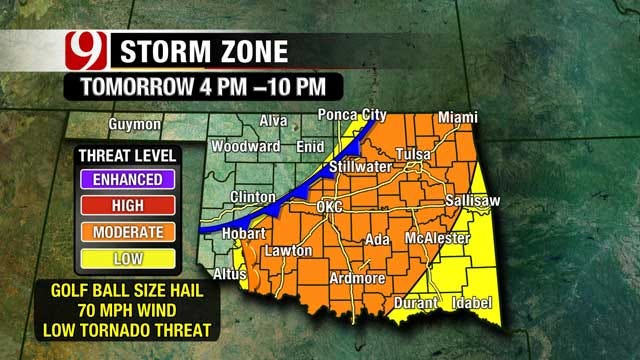
Warm weather returns Wednesday ahead of our next cold front. Partly cloudy skies and highs in the low 80s are expected in the afternoon. The dryline will be in southwest Oklahoma where early afternoon storms will fire.
Central Oklahoma will see showers and thunderstorms by late afternoon. Some of these storms will be strong to severe, with large hail and damaging wind the primary threats. There is a low tornado threat.
The best time for the metro to see these storms will be from 4 p.m. to 7 p.m. These storms will rapidly push east through the evening.
Mostly sunny skies return on Thursday with cooler highs in the low 60s.
Stay with News 9, we'll keep you advised.

Get The Daily Update!
Be among the first to get breaking news, weather, and general news updates from News 9 delivered right to your inbox!
More Like This

March 24th, 2015

March 22nd, 2024

March 14th, 2024

February 9th, 2024
Top Headlines

April 18th, 2024

April 18th, 2024

April 18th, 2024