Another Round Of Severe Weather On The Way To Oklahoma
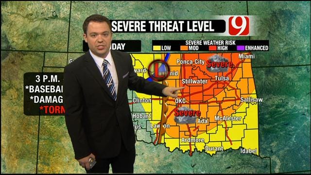
The dryline will push into central Oklahoma early this afternoon, setting up shop along or just west of I-35. Wherever it decides to set up, that's where we'll have storms.Sunday, May 19th 2013, 9:26 am

Another May day, another round of severe weather on the way. Par for the course here in Oklahoma.
Today is a bit different than yesterday, primarily in terms of where the storms will set up. The dryline will push into central Oklahoma early this afternoon, setting up shop along or just west of I-35. Wherever it decides to set up, that's where we'll have storms.
This puts the OKC Metro at risk to see some of these storms. Once the dryline moves east of your area, the severe threat for today will decrease rapidly.
Much like yesterday, as storms form, they'll become severe in a hurry. This means large hail, up to the size of baseballs, and potentially damaging winds up to 70 mph.
As the afternoon and evening progress, the potential for tornadoes will increase, which means northeastern Oklahoma, including Tulsa, will be at risk through tonight. Storms could start as early as 2-3 p.m. or as late at 5 p.m. Just remember, once they form, severe isn't too far behind.
Have your severe weather plan ready to go and make sure you have a way to receive warnings this afternoon.
Stay with News 9, we'll keep you advised.

Get The Daily Update!
Be among the first to get breaking news, weather, and general news updates from News 9 delivered right to your inbox!
More Like This

May 19th, 2013

March 22nd, 2024

March 14th, 2024

February 9th, 2024
Top Headlines


April 16th, 2024