Tracking A Chance Of Rain To Snow
Heavy rain has moved out, but another fast-moving system could soon bring shower chances back to Green Country.Thursday, February 9th 2023, 6:40 am


If you’re into podcasts or in a rush, check out my daily weather update. Search for NewsOn6 and ‘Weather Out The Door’ on most podcast providers, including Spotify, Stitcher and Tune-In, or Click Here to listen on Apple Podcasts.
TULSA, Okla. - Heavy rain has moved out, but another fast-moving system could soon bring shower chances back to Green Country.
Here are the details from News On 6 Meteorologist Alan Crone:

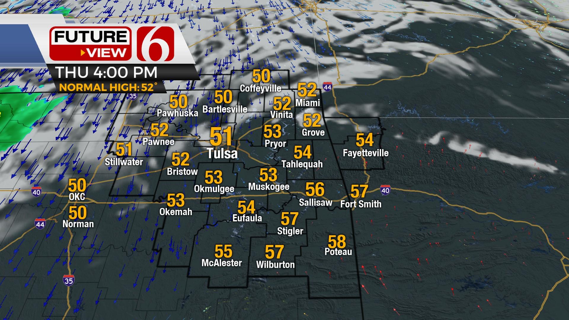
Clouds clear early Thursday morning with sunny conditions midday. Breezy northwest winds arrive with highs in the upper 40s and lower 50s before our next system quickly moves into the area later Thursday night bringing probabilities for light snow. A stronger system arrives early next week with additional rain and thunder probabilities.

The main upper-level system that kept us wet and chilly the past 48 hours has exited the area to our northeast. This brings gusty northwest winds this morning with decreasing clouds and highs reaching the upper 40 and lower 50s. Another fast upper-level trough will quickly clip the area later tonight into early Friday morning bringing a chance for some light showers changing to snow trough pre-dawn Friday. The most recent model runs have shown more in the way of potential snow production. Part of the system seems a little slower compared to previous runs, and this should allow the system to have more moisture available as it moves across the area later tonight into pre-dawn Friday morning. The air aloft hasn't changed much but will be cold enough for snow production from column cooling. We're increasing the probabilities for light snow later this evening into Friday, including mentions for some slushy accumulation in grassy areas. A generalized forecast of anywhere from a half to nearly 1 inch will be possible. Some point soundings suggest a small pocket of elevated instability that could produce a lightning strike or two. If this happens, someone could pick up a quick burst of 1-to-2-inch snowfall. I'll fashion the maps for some slightly higher totals across far northeastern OK and northwestern Arkansas, but most of the area will be represented by a dusting to near 1/2 for any snowfall that occurs.

This will also keep us colder with Friday afternoon highs staying in the upper 30s to lower 40s with another brisk northwest wind. Clouds will clear Friday afternoon and set the stage for very cold weather through Saturday morning. Saturday morning lows will drop into the upper teens and lower 20s. Daytime highs will reach the lower or mid-50s with sunshine and south winds from 10 to 15 mph. Stronger south winds return Sunday with increasing clouds and highs nearing 60s before our next strong storm system influences the area Monday evening into Tuesday with more rain and thunder, including the potential for locally heavy rainfall again across southeastern OK and east central sections. If the system slows down, the potential for strong to near-severe storms will sneak into the Red River Valley. The pattern will bring another wintry-looking system into the central plains later next week.

Thanks for reading the Thursday morning weather discussion and blog,
Have a super great day!
Alan Crone
KOTV

Get The Daily Update!
Be among the first to get breaking news, weather, and general news updates from News 9 delivered right to your inbox!
More Like This
February 9th, 2023


April 19th, 2024

Top Headlines

April 19th, 2024


