Active Weather Pattern Remains
A cool and foggy morning is expected on Monday before a cold front arrives in the afternoon hours.Monday, December 5th 2022, 6:49 am
TULSA, Okla. -
If you’re into podcasts or in a rush, check out my daily weather update. Search for NewsOn6 and ‘Weather Out The Door’ on most podcast providers, including Spotify, Stitcher and Tune-In, or Click Here to listen on Apple Podcasts.
TULSA, Okla. - A cool and foggy morning is expected on Monday before a cold front arrives in the afternoon hours.
Here are the details from News On 6 Meteorologist Alan Crone:

A cold front arrives this afternoon and moves across the northern third of the state before stalling south tonight. This boundary will bring a broad range of temperature the next few days with cooler weather north and milder conditions south. Wednesday a disturbance nears the area with increasing rain and thunder chances as the boundary slowly lifts north. Pockets of moderate to perhaps locally heavy rainfall become likely Wednesday and maximizing Wednesday evening into pre-dawn Thursday before the system exits the region. Another system nears the state this weekend with scattered rain and thunder chances beginning late Friday evening into Saturday.

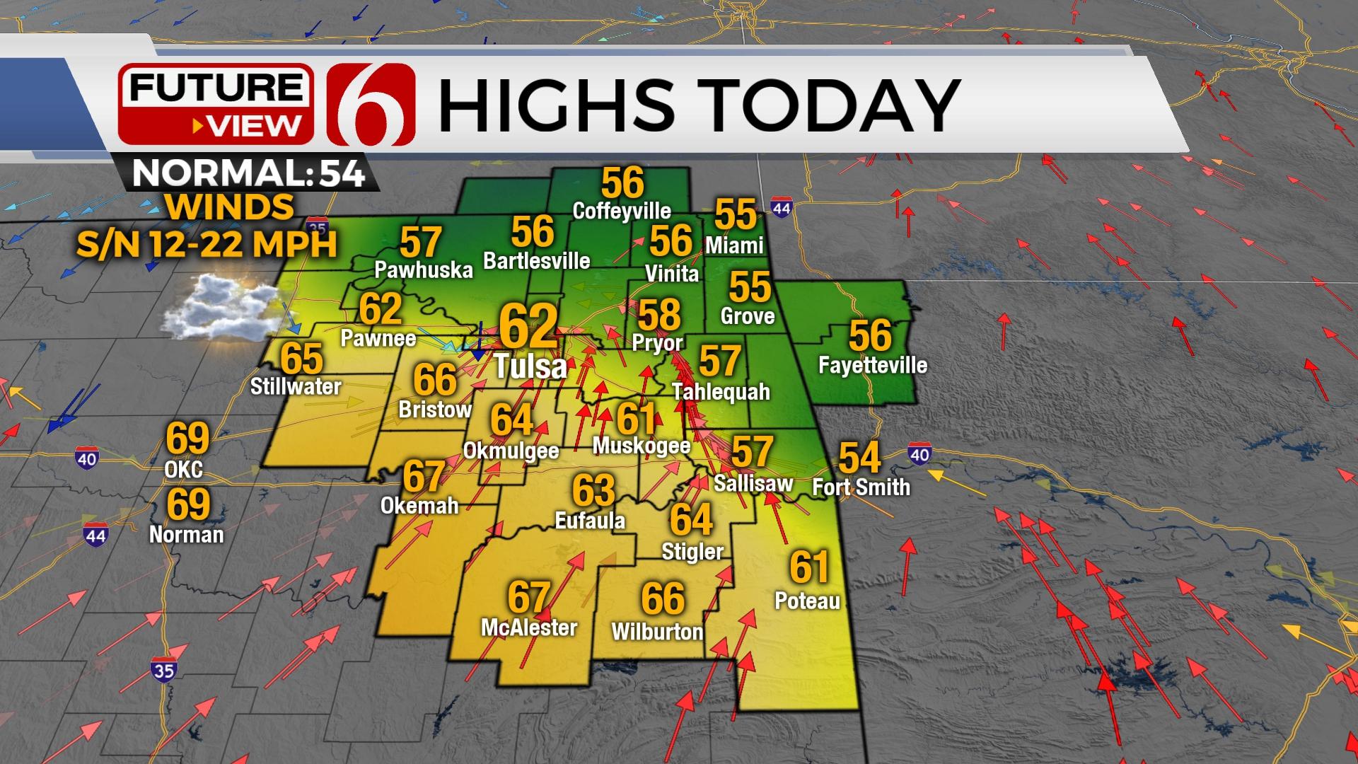
Temperatures will remain cool on Monday morning with patchy fog and even some light precipitation across the southern third of the region. Dense fog is possible. Use caution while driving during the early to mid-morning hours.

South winds will become slightly breezy midday with winds from 12 to 22 mph before decreasing in speeds this afternoon as the boundary moves across southern Kansas into northern Oklahoma. Winds along and behind this front will back from the northeast at 10 to 15 mph. Daytime highs will remain cooler north and milder south due to the boundary. Locations across far northern OK will remain in the lower to mid-50s. Southeastern to central Oklahoma will see highs in the upper 60s to near 70. Tuesday morning lows will be in the 30s north and 50s south. Tuesday afternoon highs will be in the lower 50s north and 60s south.

A southwesterly upper air flow brings a disturbance near the state Wednesday into Thursday with moisture lifting near and over the surface boundary. Model projections support the possibility of some locally heavy rainfall near or slightly north of the boundary. Severe weather parameters will be poor during this period, but a few storms will remain possible.
Friday night into the weekend yet another system nears with increasing rain and thunder probabilities Saturday. Colder weather is possible late in the weekend into next week.
Thanks for reading the Monday morning weather discussion and blog.
Have a super great day!
Alan Crone
KOTV

Get The Daily Update!
Be among the first to get breaking news, weather, and general news updates from News 9 delivered right to your inbox!
More Like This
December 5th, 2022

April 23rd, 2024

April 23rd, 2024

April 23rd, 2024
Top Headlines

April 23rd, 2024

April 23rd, 2024


April 23rd, 2024
