Road Conditions Deteriorating In Western Oklahoma As Ice Storm Moves Through
<p>4:00 a.m. Patchy freezing rain continues to develop in central and southern Oklahoma. Temperatures are below freezing along a line from Hobart to Chickasha to Norman to Shawnee and points to the north. All of the Oklahoma City metro is below freezing. At this time, the rain is battling dry air. That will not be the case over the next hour or so. Bridges and elevated surfaces will be the first to get slick. </p>Friday, January 13th 2017, 5:03 am


11 a.m.
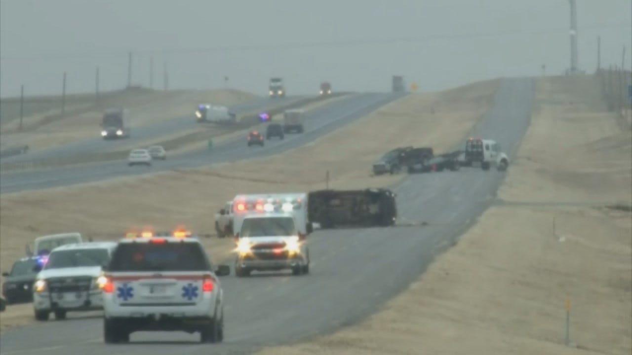
Storm Tracker Marty Logan says a vehicle rolled over in the eastbound lanes of I-40 between Clinton and Weatherford. Right now in that area, heavy freezing rain is falling with temps in the mid 20s. I-40 is VERY quickly becoming a skating rink under the heavy freezing rain.
Just after 11:30 a.m., a violent rollover was captured by Marty on I-40. And later, as emergency personnel were attending to that wreck, another vehicle lost control and crashed just up the highway. In all, Marty has witnessed five crashes on I-40, just west of Weatherford and road condtions are only expected to get worse throught the afternoon and evening hours.
--
9:40 a.m.
Light scattered freezing rain showers continue moving northeast across the state. Heaviest showers right now are in western Oklahoma. Freezing rain will remain scattered today before heaviest precipitation arrives tonight into tomorrow. The meat of this storm is still on the way!
--
8:33 a.m.
Scattered, freezing rain showers continue through central Oklahoma. Icy spots are starting to increase across the Oklahoma City metro. This is just the beginning of the event. Heavier freezing rain is expected this evening into tonight, which will likely make the roads a lot worse.
--
7:45 a.m.
Intermittent showers expected now through 10 a.m., causing elevated surfaces to become slick and icy. Some trees and power lines are beginning to collect ice in northern parts of Oklahoma.
--
7:10 a.m.
Today will mainly showcase intermittent freezing drizzle and freezing rain, as expected. The heavier precipitation arrives tonight into tomorrow morning and again Saturday night into Sunday. More significant ice accumulations are expected tonight as the precipitation becomes heavier.
--
6:55 a.m.
Current temperatures across the viewing area are mainly below freezing, but road temperatures through central Oklahoma are still above freezing. That mean means the treated roads are still in good shape, just wet for now. Temperatures are not expected to be above freezing today. Light scattered rain showers will continue off and on throughout the day. Heavier precipitation arrives tonight.
--
6:31 a.m.
Scattered, freezing rain showers continue moving northeast across the state with the heaviest showers in far northeastern Oklahoma. Roads temperatures are at and below freezing mainly in far western and northern Oklahoma. Roads are still mainly wet in Oklahoma City thanks to efforts by the Oklahoma Department of Transportation to treat them overnight. However, slick spots are still likely, especially across bridges and overpasses
--
6:13 a.m.
Air temperatures are below freezing along and northwest of I-44, while roads temps are still above freezing through Oklahoma City. As a result main roads are still mainly wet. Bridges and overpasses will have slick spots where the rain has been falling. Not everyone has seen rain this morning. Scattered showers will continue off and on throughout the day.
--
6:00 a.m.
NextGen Live radar shows the first wave of rain and drizzle winding down. Roads are wet and some bridges and overpasses are icy.
--
5:20 a.m.
Light, scattered showers and freezing drizzle is falling in central Oklahoma now. Roadways are wet, but bridges and overpasses are becoming icy.
--
4:50 a.m.
Freezing rain increasing over central Oklahoma. Road temperatures are just above 32 degrees. Slick roads more likely over next one to two hours.
--
4:00 a.m.
Patchy freezing rain continues to develop in central and southern Oklahoma. Temperatures are below freezing along a line from Hobart to Chickasha to Norman to Shawnee and points to the north. All of the Oklahoma City metro is below freezing. At this time, the rain is battling dry air. That will not be the case over the next hour or so. Bridges and elevated surfaces will be the first to get slick.

Get The Daily Update!
Be among the first to get breaking news, weather, and general news updates from News 9 delivered right to your inbox!
More Like This

January 13th, 2017

March 22nd, 2024

March 14th, 2024

February 9th, 2024
Top Headlines

April 18th, 2024

April 18th, 2024

April 18th, 2024

