Meteorologist Jed Castles: More Snow, Sleet On Wednesday In Oklahoma
It appears to me this will be the biggest winter event of the season with the highest opportunity for snow and sleet totals. Will this be classified as a winter storm? The NWS says not yet, I am saying maybe.Tuesday, March 3rd 2015, 9:28 am


It appears to me this will be the biggest winter event of the season with the highest opportunity for snow and sleet totals. Will this be classified as a winter storm? The NWS says not yet, I am saying maybe.
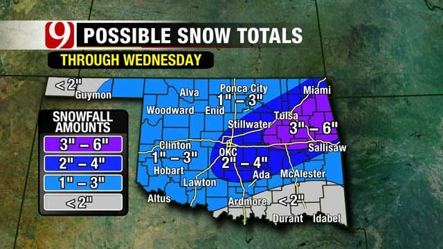
Eastern OK is the better area for that criteria. But it comes close to OKC. Looks like a classic I-44 March event with the heaviest precip along the turnpike NE of OKC.
The Moving Parts: The Arctic Cold Front and a strong Low to our southwest. The front will slide through OK this evening... OKC around 9 PM. A low pressure area that brought a rare hail event to LA yesterday will swing our way and move across tonight and tomorrow. This will ride over the top of the arctic air.
Overnight through 6 AM: Rain will develop tonight and I do not seeing roads drying out at all before morning. This will transition into freezing rain and sleet after midnight as temperatures nose dive below 32 degrees. So, roads especially elevated surfaces will begin freezing up once we hit the freezing mark.
6 AM to Noon: We will start the morning off with temperatures below 32 degrees and roadways in the process of freezing over. Areas of freezing rain and sleet will continue to create hazardous roadways.
Noon to 9 PM: Roads will be tough going by Noon because of the precip that has fallen. Snow will take over after lunch time. This is the most challenging part of the forecast. Some data cut the snow chances off right after they start and others kick in a lot more snow. I'm thinking some around 1-3 or 2-4 inches for the metro.
If the sleet dominates into the afternoon, the snow total will be closer to one inch. If the snow takes over early, the total will be closer to four inches.
Snowfall Ratio: The typical snowfall to water ratio - at 32 degrees - is 10 inches of snow to 1 inch of liquid. Temps will fall into the 20's during the day. This puts the snowfall ratio at 15 inches of snow to 1" of liquid. Forecasting between .1 to .25" of liquid for snowfall which equals about 1.5 to 4" of snow for the OKC metro.
So there are still some things to pin down, ahead of Wednesday.
I am pretty much locked in on worsening road conditions during the morning. Still waiting for more data to firm up the snow profile for Wednesday.
Stay with News 9 and News9.com. We will keep you advised.

Get The Daily Update!
Be among the first to get breaking news, weather, and general news updates from News 9 delivered right to your inbox!
More Like This

March 22nd, 2024

March 14th, 2024

February 9th, 2024
Top Headlines


April 18th, 2024

April 18th, 2024

